


2022 WORLD RALLY FLYING CHAMPIONSHIPS DAY TWO
By Tarryn Myburgh
Google Banner Ad
The afternoon session is always mentally tough. We still need to be at the competitor briefing at 7:30a.m. Directly after this, we go into quarantine until 'papers' time. When flying in the afternoon session, quarantine can be up to 6 hours. With no electronics, you need to find other ways to occupy yourself. Each person is different and may want to chat, to sleep, read, meditate or play a game.
During this time, I try to carefully manage my nerves, physical energy levels and hydration. If I become too distracted, it becomes difficult to kick start my brain later. But I need to distract myself from the nerves as stress uses a lot of energy. Quarantine is in a large hangar that becomes a bit like an oven, so hydrating is important; however, the more water you drink, the more bathroom trips you need. Each trip is accompanied by an official to ensure we aren't hiding some secret information or communication device in the sun-baked temporary toilets. Lastly, what you eat before a potentially turbulent flight could be critical. We don't need to add nausea to the cockpit workload. Been there, done that and it is no fun at all!
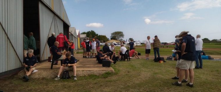
Waiting to enter quarantine. The rest of the wait will look a lot like this, but without phones.
I prefer to have a large breakfast and then stick to snack bars before our flight. I also prefer to alternate chatting and reading to keep myself busy. Today in quarantine, a pilot from the Czech team that flies directly after us asks if I can try to shorten the time for my circuit and landing when returning to the airfield. This will give them more time on the ground to complete their answer sheet. This is a very seriously competitive team, so I give it some thought. The spot landing is something that is practiced to a fine art. Unless I land after my landing time, any changes will be out of courtesy. If I can do anything faster, I will but I decide to try to ignore the request as far as possible as I don't want to mess up my carefully planned landing procedure.
THE CONDITIONS
I am so relieved that a much better flying day is predicted for today. With our beautiful sunny South African weather finally making an appearance, we will need to keep ourselves and the aircraft cool for a few hours. The light wind means we can use the preferred downhill runway 20 for take-off, and the preferred runway 02 for the landings. The morning starts off partly cloudy, but soon clears up. Our take-off time is only 12:54p.m., so we are concerned that our flight might be hot and turbulent. Mercifully, we remember to put the aircraft cover on to reduce the heat in the cockpit a bit.
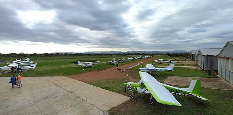
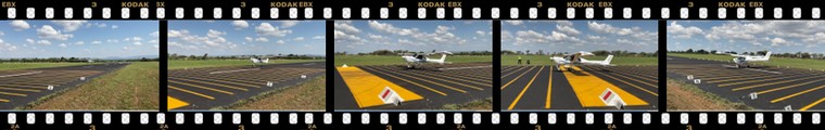
A cloudy start to the morning
The start list gets published each morning before we go into quarantine. Each team gets a physical paper copy, and this is used in combination with the 'master clock' to set your stopwatches to your particular take-off time. This is critical! Get it wrong and your whole day can be ruined before you even take off.
In addition, this start list provides your 'papers' time. During the competitor briefing we learned that the organisers have given us 2.5 minutes per turn point for today's route. The start list shows that we have 43 minutes from papers time to take-off time, which means we have a whopping 17 checkpoints to complete today. Typically, a route has 8-13 turn points.
"Does that mean that we are flying for much longer today?" I ask Iaan, confused. He double checks the total flight time to see it remains the standard 1.5 hours. I realise that this route will have a lot of short legs, requiring intense focus to stay on top of navigation and timing. There is no room for error on a short leg and every mistake will quickly snowball.
We get our papers promptly at 12:11p.m. I stand outside the aircraft door to give Iaan as much space as possible to plot in our cramped cockpit. I don't notice that I spend the entire plotting time with only my legs not protected by the shade of the aircraft wing. Only this evening will I realise that I put sunblock everywhere except my legs. Ouch!
The plot is not too difficult, and Iaan is making good progress, but the sheer number of turn points requires prolonged and intense concentration. The short legs and sharp turns mean that keeping the plot tidy and legible is a difficult task.
Keep the plot tidy!
I, on the other hand, have way more time than normal to prepare the turn point and en route photos. For a change, I have time to examine each one. It is quite a bizarre feeling as I normally only have enough time to cut them out, stick them up and then it is time to start up the engine. I use the additional time to try to memorise each photo and identify distinct features. I am able to compare each en route photo and each turn point photo, hoping to reduce some of the workload while flying. I notice that two turn point photos are identical, meaning that at least one must be incorrect.
Our standard procedure is that after 4 legs, Iaan hands me the map to complete my own minute markers and to familiarise myself with the start point. Typically, he finishes the plot soon after we become airborne, but we stick to the split map in case he hits a snag somewhere late in the plot. Having a partial map means that I can fly alone if he needs more time to complete the map once we are airborne.
Today, we make an exception and base the handover on time. Iaan finishes an additional 5 turn points before handing the map to me. I mark it up and try to fold the map very specifically to try avoiding confusion in the air. Having a fold at a turn point can mean that the next leg is not visible. Do I turn left or right? Unfolding the map at that moment can very easily lead to you losing your place and moments later, you are disoriented.
Today's route, called the Chrome Route, starts west of the airfield in the Langberg Valley. The route planner, a geology enthusiast, has named each route based on the dominant minerals along our route. As a geologist myself, who has worked extensively in this area, I know we are headed west today on a tour over one of the largest platinum and chrome deposits in the world, the Bushveld Complex.
As I guessed, the route heads west towards Rustenburg, turns south-west to an area we have never flown in before, before returning east back to Brits. In a series of zig zags, we will fly over numerous mining operations, waste dumps, small and large mining towns and some of the major dams in the area.
FIRST HALF
The start of the route feels relatively routine and relaxed. I know the start point, having flown over it in practice and am two seconds early for a bingo. I identify the photo correctly and continue towards turn point 1. It is rather tricky to find. The turn point is a road river crossing that is obvious on the map but in reality, is behind quite a large hill, and the normally distinct green riverbed is disguised by the lush green bush from the recent rains. I am slightly disappointed that we fly over it 8 seconds early, but at least we correctly identify it.
Turn point 2 is another really tricky one, a river confluence. This is particularly difficult for me to identify from the air. One large river is obvious, but I can't see the second river at all. The turn point is not far past the town of Bethanie and so I rely on our timing instead. As we count down the seconds, I look down and try to identify if the clump of bush below looks like the turn point photo. I am not sure, but Iaan assures me he saw it and it is correct. He marks it and we move on.
Turn points 2, 3 and 4 are completed within 4 seconds of the target times. We fly over a small but distinct dam that we know well, past the Marikana Granite Quarry to a beacon on top of a hill. We know from yesterday that the beacon must be visible in the photo, making identification slightly easier. The route skirts past a few townships and takes us over terrain varying from farmland to unpopulated veld (dry grassland).
We zig zag left and right through each turn point, trying to navigate and remain on time, but the high workload of the short legs and sharp turns means that we are missing photos and ground markers. I may have studied them, but I don't have the capacity to look for them. I am also distracting Iaan by pulling him into navigation and identification of the difficult turn points.
The next leg is an arc with turn point 5 at the inflow point of the Bospoort Dam, a dam I had never heard of before we started flying over it regularly. I am still managing our timing well and bingo turn point 5. Iaan again identifies the turn point photo as incorrect, after spotting the red herring photo on the other side of the dam. Another bingo follows at turn point 6, located just before the town of Rustenburg. I think I see a ground marker but I can't identify it. Unable to mark it means we still score the penalties but our confidence levels remain high, excited that we actually saw it!
Leg 7 is our second arc, and it takes us over the northern parts of the town of Rustenburg. This is a large mining town that has formed based on the mining in the area. On our competition maps, a town or city is shown as a yellow area showing only the outline of the town. This yellow blob on the map hides roads, rivers, schools and other useful navigation features, leaving only the shape of the town to navigate by. In areas like Rustenburg, the town has grown significantly since the maps were last updated in 2015 (this is South Africa after all). Navigation becomes rather intense, and I have to share the workload of navigating the arc, again costing us on the observations. I arrive at the farmhouse 11 seconds early, costing us 27 penalty points. I confidently pronounce the photo as incorrect (to find out later that I am wrong).
The next leg pops out west of Rustenburg into an area right off our practice maps. It is a featureless area to the southwest of Rustenburg. This is a bit of a surprise for us. As the last of the town, roads and farms disappear behind us, there is nothing to maintain timing with. Green bush everywhere, I distract Iaan once again and we work out that the turn point must be behind a small hill, of course. As I pop out over the hill, I see the turn point and realise that we are very early but there is almost no space to lose time. I try my best to slow down, I add flaps and pitch the nose up to convert speed into height, but we still cross the turn point 22 seconds early. Only after all teams were scored did we find out that several teams protested the turn point, and it was thrown out of the competition. Apparently, the timing point was not exactly where it should have been, although we would never have picked that up. That saved us 160 points because in addition to the timing, I also got the turn point photo wrong again. Fatigue is starting to set in as we reach the halfway mark.
SECOND HALF
We forget to replace the photo board until we are well into the next leg. When we finally get the second board up, we realise from the landscape that we definitely missed some en route photos. We are flying over lush green farming areas near the Olifantsnek Dam. We don't anticipate many more farms as the rest of our route appears to take us over heavily disturbed mining areas all the way back to Brits.
Another left turn and we are now headed back towards Rustenburg passing through the Olifantsnek, a deep valley through the Magaliesburg mountains just to the north of the Olifantsnek Dam. This is one of our longest legs and I have some clear features to navigate by, giving me a moment to pause. I realise that I am sweating profusely and that studying the photos before take-off hasn't helped as I haven't spotted a single one. I see my note on the next turn point photo showing that the photo is identical to turn point 13, so one of the two must be false. Five seconds late at the turn point, I am not 100% sure about the photo. It looks right but something seems off. I tell Iaan that the photo is true, we turn right and move on.
Looking at the map, we realise that the next few legs, 10, 11, 12 and 13, will be very short with sharp turns. It is very important to get on track quickly and adjust early for the speed that you lose during a sharp turn. Turn point 10 is a house north of a minor road. I fly over an abandoned and crumbling building 7 seconds early and hope that was the 'house'. I do a sharp turn to the left and maintain a higher speed as we start to zig zag over the enormous Marikana platinum mine.
Turn point 11 is a powerline crossing. Not easy to spot, but we identify the turn point and fly over it 7 seconds early again. Then, disaster strikes! I get disoriented but with no time to waste, I start a sharp left turn and keep my speed up. Iaan starts to panic and shouts at me, but he can't get words out. "No, agh, not there, gah" he yells. Confused, I look at the Marikana Granite Quarry ahead of me and think: "that can't be right". We would never fly over the same thing twice in a route as there are other aircraft behind that would now be flying in the opposite direction to us. Iaan finally gets the words out to tell me to turn right, back towards the platinum mines. It takes about 10 seconds to gather ourselves, but it feels like an hour. I immediately start my turn to the right to fix the mistake and get back on track, sort of. It cost us some time, but we hope that we didn't get penalties for flying too far in the wrong direction. We arrive ten seconds late at turn point 12. Being quite far off track also costs us some obvious en route photos, one being the site of the infamous Marikana massacre. By now our brains are fried, having worked extremely hard for 2 hours already, and we still have another 4 legs left. Today is a tough one!
Somehow, we manage to recover and arrive six seconds early at the crossroads at turn point 13. The photo is definitely true so we correct turn point 9. This is followed by another two bingos at turn points 14 and 15. The mining area is petering out as we head back towards the town of Brits. It is an interesting landscape combining agriculture, industrial activity and townships. The route takes us over a busy mix of roads, canals, train lines, warehouses, processing plants and farms. The final leg takes us back over the town itself and we finish four seconds early to complete a very successful flight.
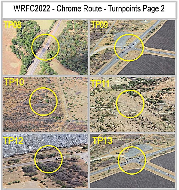
Photos 9 and 13, which one is false?
I am absolutely exhausted but with just the landing left, I try to refocus from navigation to landing mode. The experienced team members tell us to look at the hair on our arms for a moment, just to break out of the previous mind set.
I make sure that I follow the correct procedure over the airfield to avoid unnecessary penalty points. I have tried to forget the discussion during quarantine, but I still feel pressure to hurry my landing. I do a shorter circuit and am descending much faster than normal. On final approach, we are much lower over the threshold than normal. I start to get really worried that we are going to land very short of the box (but at least still on the runway). I add a small burst of power and flare hard, hoping to avoid maximum points. The power gives us a little bit of lift and we hold our breath for a few seconds before we settle onto the runway. Iaan and I look at each other, wide eyed: "That looked very close to the line, was it a bingo or minus 1 metre?" I quickly backtrack to get off the runway and out of the way. The next team are already on their base leg, are a mere minute or two from their own landing. As we pass the landing judges, they give us a huge smile and thumbs up and I start to grin.
Bingo landing!
FINAL SCORE
After an excellent flight, we score 144 penalty points for timing and our perfect landing gives us a sought after zero penalty points. Iaan is not satisfied with our observations yet again. We made two turn point photo mistakes but mercifully for us, one is removed from the results. We did not identify a single ground marker and have only seen eight en route photos. Even more disappointingly, the fact that we skimmed over checking the answers means that we have marked two en route photos incorrectly. This incurs an additional 40 points more than if we left them out completely. This gives us an observation score of 650 penalty points. I know how much attention the navigation took from both of us, so this doesn't bother me in the slightest, and I am so excited by my bingo landing that I just can't be disappointed with the day!
Back at the clubhouse, the war stories begin. One of the South African teams set their watch exactly 1 minute out and got a maximum score for every single timing point. Another handed their answer sheet in a few seconds late, earning themselves 200 penalty points. This is why I am fanatical about setting multiple stopwatches during quarantine.
Our overall score for the day is 794, placing us in 22nd on the day and 5th of the South African teams. A fantastic result for us and although exhausted, we can't wait for Day three!
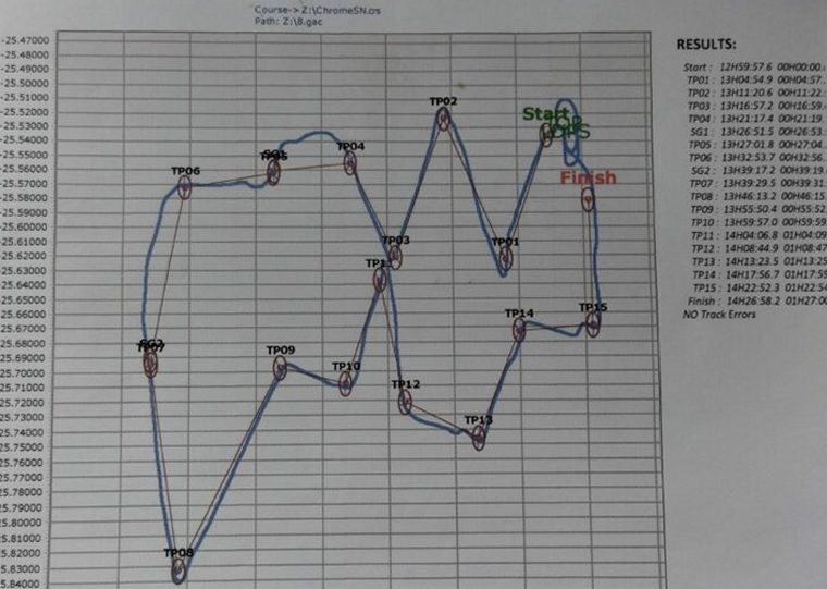
Our track over the Day 2 route
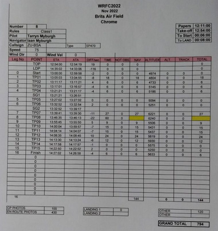
A breakdown of our scores for Day two
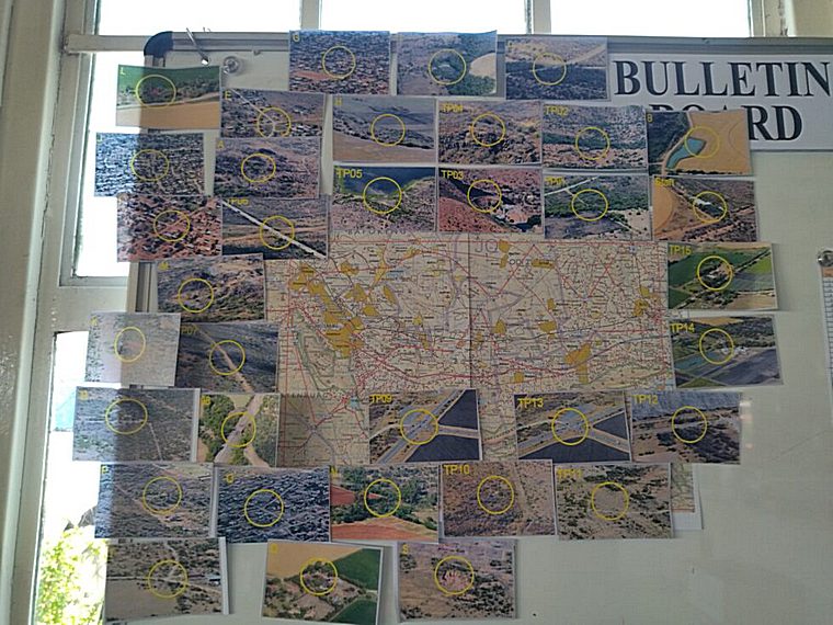
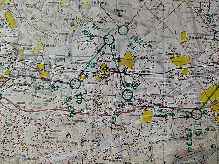
The master map showing the route and the location of the photos for Day two
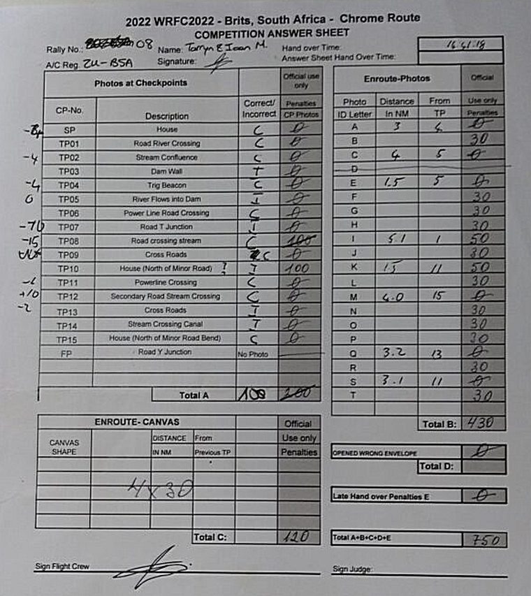
A scruffy answer sheet
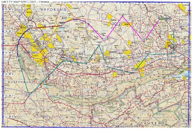
The Day 2 Route
Google Banner Ad

 |
 |
 Copyright © 2024 Pilot's Post PTY Ltd
The information, views and opinions by the authors contributing to Pilot’s Post are not necessarily those of the editor or other writers at Pilot’s Post.
Copyright © 2024 Pilot's Post PTY Ltd
The information, views and opinions by the authors contributing to Pilot’s Post are not necessarily those of the editor or other writers at Pilot’s Post.